
Mapa topográfico Red Feather Lakes
Mapa interactivo
Haga clic en el mapa para ver la altitud.
Acerca de este mapa
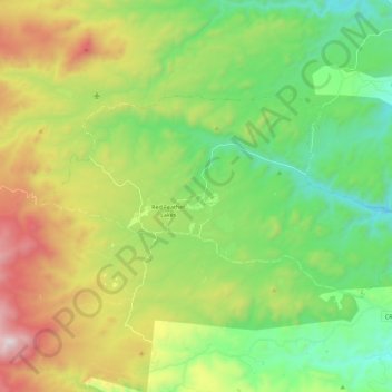
Nombre: Mapa topográfico Red Feather Lakes, altitud, relieve.
Altitud media: 2 551 m
Altitud mínima: 2 137 m
Altitud máxima: 3 314 m
Red Feather Lakes is located in north-central Larimer County at 40°48′28″N 105°34′43″W / 40.80778°N 105.57861°W / 40.80778; -105.57861 (40.807820, -105.578641), at an elevation of 8,100 to 8,500 feet (2,500 to 2,600 m). Via Red Feather Lakes Road, it is 24 miles (39 km) west of U.S. Route 287 at Livermore and 45 miles (72 km) northwest of Fort Collins, the county seat.