
Haz una donación
Mapa topográfico Inglis
Haga clic en el mapa para ver la altitud.
Haz una donación
Acerca de este mapa
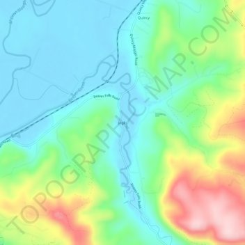
Nombre: Mapa topográfico Inglis, altitud, relieve.
Lugar: Inglis, Columbia County, Oregon, United States (46.10650 -123.18512 46.14650 -123.14512)
Altitud media: 76 m
Altitud mínima: -3 m
Altitud máxima: 252 m
Haz una donación
Otros mapas topográficos
Haga clic en un mapa para ver su topografía, su altitud y su relieve.
Vernonia
United States > Oregon > Columbia County
The city has been severely impacted by floods on multiple occasions. The rains that caused the Willamette Valley Flood of 1996 flooded Vernonia as well; some homes in the floodplain were elevated, and some flooring materials were replaced, mitigating some damage from later flooding. In 2007, heavy storms that…
Altitud media: 218 m
Haz una donación
Vernonia
United States > Oregon > Columbia County
The city has been severely impacted by floods on multiple occasions. The rains that caused the Willamette Valley Flood of 1996 flooded Vernonia as well; some homes in the floodplain were elevated, and some flooring materials were replaced, mitigating some damage from later flooding. In 2007, heavy storms that…
Altitud media: 218 m
Haz una donación
Haz una donación