
Mapa topográfico Scranton
Mapa interactivo
Haga clic en el mapa para ver la altitud.
Acerca de este mapa
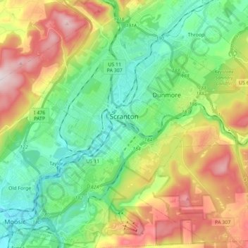
Nombre: Mapa topográfico Scranton, altitud, relieve.
Lugar: Scranton, Lackawanna County, Pennsylvania, United States (41.33963 -75.72002 41.46933 -75.60387)
Altitud media: 360 m
Altitud mínima: 183 m
Altitud máxima: 675 m
Center City is about 750 feet (229 m) above sea level, although the hilly city's inhabited portions range about from 650 to 1,400 feet (200 to 430 m). The city is flanked by mountains to the east and west whose elevations range from 1,900 to 2,100 feet (580 to 640 m).