
Mapa topográfico Georges Township
Mapa interactivo
Haga clic en el mapa para ver la altitud.
Acerca de este mapa
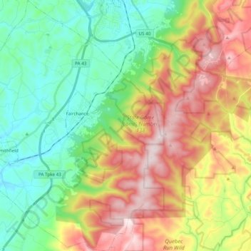
Nombre: Mapa topográfico Georges Township, altitud, relieve.
Altitud media: 506 m
Altitud mínima: 289 m
Altitud máxima: 846 m
Georges Township is in southwestern Fayette County. It surrounds the boroughs of Fairchance (near the center of the township) and Smithfield (in the southwest). Pennsylvania Route 43 (the Mon–Fayette Expressway), U.S. Route 119, and Pennsylvania Route 857 cross the township, running roughly parallel. All lead northeast to Uniontown, the county seat. US 119 leads southwest to Point Marion, Pennsylvania, and Morgantown, West Virginia, while the Mon–Fayette Expressway provides a quicker route to Morgantown via Interstate 68 in West Virginia. The eastern boundary of Georges Township runs close to the crest of Chestnut Ridge, reaching a peak elevation of 2,760 feet (840 m). The lowest elevation in the township is 930 feet (280 m) along Georges Creek where it exits the township south of Smithfield.
Otros mapas topográficos
Haga clic en un mapa para ver su topografía, su altitud y su relieve.
Farmington
United States > Pennsylvania > Fayette County > Wharton Township
Farmington, Wharton Township, Fayette County, Pennsylvania, 15437, United States
Altitud media: 580 m