
Haz una donación
Mapa topográfico State College
Haga clic en el mapa para ver la altitud.
Haz una donación
State College
State College is situated at an elevation of approximately 1,200 feet (370 m) above sea level. According to the U.S. Census Bureau, the borough has a total area of 4.5 square miles (12 km2), all of it land. It is surrounded by large tracts of farmland, and an expanse of Appalachian Mountain ranges and forests. Its location within a valley makes it prone to frequent rain and snowfall. Nittany Mountain is part of Pennsylvania's geologic ridge-and-valley province of the Appalachian Mountains. It is (approximately) the geographic center of Pennsylvania.
Haz una donación
Acerca de este mapa
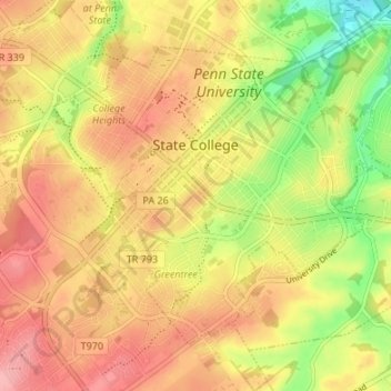
Nombre: Mapa topográfico State College, altitud, relieve.
Lugar: State College, Centre County, Pennsylvania, United States (40.76837 -77.88617 40.80723 -77.81900)
Altitud media: 351 m
Altitud mínima: 286 m
Altitud máxima: 398 m
Haz una donación
Otros mapas topográficos
Haga clic en un mapa para ver su topografía, su altitud y su relieve.
Dalevue Park
United States > Pennsylvania > Centre County > State College > Dalevue
Altitud media: 331 m
Haz una donación
Loch Lomond Junction
United States > Pennsylvania > Centre County > Rush Township
Altitud media: 460 m