
Gracias por apoyar a este sitio ❤️
Haz una donación
Haz una donación
Mapa topográfico Long Pond
Haga clic en el mapa para ver la altitud.
Gracias por apoyar a este sitio ❤️
Haz una donación
Haz una donación
Long Pond
Long Pond is named after the wetland topography formed by Tunkhannock Creek. Within the Long Pond community are public access lands, containing many species of plants and animals. Long Pond has been called "the most unique inland freshwater wetland in the state".
Gracias por apoyar a este sitio ❤️
Haz una donación
Haz una donación
Acerca de este mapa
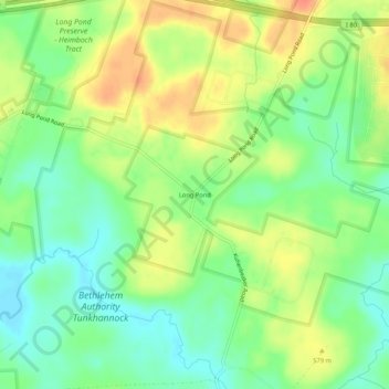
Nombre: Mapa topográfico Long Pond, altitud, relieve.
Altitud media: 571 m
Altitud mínima: 550 m
Altitud máxima: 596 m
Gracias por apoyar a este sitio ❤️
Haz una donación
Haz una donación
Otros mapas topográficos
Haga clic en un mapa para ver su topografía, su altitud y su relieve.
Indian Mountain Lake
United States > Pennsylvania > Monroe County > Tunkhannock Township > Indian Mountain Lake
Altitud media: 506 m