
Haz una donación
Mapa topográfico Kings County
Haga clic en el mapa para ver la altitud.
Haz una donación
Acerca de este mapa
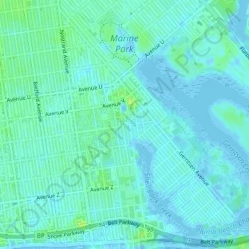
Nombre: Mapa topográfico Kings County, altitud, relieve.
Lugar: Kings County, New York, United States, Marine Park (40.58417 -73.93906 40.60938 -73.90842)
Altitud media: 4 m
Altitud mínima: -5 m
Altitud máxima: 12 m
Haz una donación
Otros mapas topográficos
Haga clic en un mapa para ver su topografía, su altitud y su relieve.
Freshkills Park
United States > New York > New York
The initial plan was to raise the elevation of the land by filling for three years and then to redevelop it as a multi-use area with residential, recreational, and industrial components. However, three years turned into fifty years. New York City's population was growing and generating more trash and it was…
Altitud media: 11 m
Haz una donación
Flushing Meadows-Corona Park
United States > New York > New York
Around 1907, contractor Michael Degnon, whose firm constructed the Williamsburg Bridge, the Cape Cod Canal, and the Steinway subway tunnel (used by today's 7 and <7> trains), purchased large tracts of marsh near Flushing Creek. At the time, the land was considered "all but worthless". Degnon envisioned…
Altitud media: 15 m
Kissena Park
United States > New York > New York
Kissena Park's natural features were formed during the Wisconsin glaciation, about 20,000 years ago. The site of Flushing Meadows–Corona Park, slightly west of Kissena Park, was originally part of the ancestral path of the Hudson River, and the present-day Kissena Lake was located on the eastern shore of the…
Altitud media: 16 m
Haz una donación
Haz una donación
Haz una donación