
Haz una donación
Mapa topográfico Ahuehuetitla
Haga clic en el mapa para ver la altitud.
Haz una donación
Acerca de este mapa
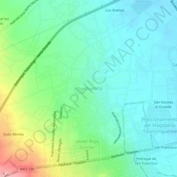
Nombre: Mapa topográfico Ahuehuetitla, altitud, relieve.
Lugar: Ahuehuetitla, Hidalgo, 43700, Mexico (20.06389 -98.43722 20.10389 -98.39722)
Altitud media: 2 183 m
Altitud mínima: 2 144 m
Altitud máxima: 2 290 m
Haz una donación
Otros mapas topográficos
Haga clic en un mapa para ver su topografía, su altitud y su relieve.
Huasca de Ocampo
The municipality extends from the Sierra de Pachuca mountains, where the town is, to over part of a wide, flat valley with lower altitude and warmer temperatures. This area is filled with small towns and villages, as well as fields and orchards. The higher elevations around these flat lands are forested with…
Altitud media: 2 208 m
Tenango de Doria
The municipality is located to the east of Hidalgo between the parallels 20° 15’ and 20° 25’ of north latitude; the meridians 98° 05’ and 98° 20’ of west longitude; with an altitude between 700 and 2800 meters above sea level. This municipality has an area of 176. 61 km² and accounts for 0.85% of…
Altitud media: 1 597 m
Haz una donación
Acatlán
As the municipal seat, the town of Acatlán is the governing authority for about sixty five other communities (INEGI) which cover an area of 174.70 km2. However, as of 2005, only 418 out of the total municipal population of 17914 lives in the town proper (INEGI). The municipality borders the municipalities of…
Altitud media: 2 195 m
Haz una donación