
Mapa topográfico Allenspark
Haga clic en el mapa para ver la altitud.
Allenspark
Allenspark is located in northwest Boulder County within Roosevelt National Forest in the Front Range of the Colorado Rockies. The western edge of the community is the boundary of Rocky Mountain National Park. State Highway 7 passes through the community, leading north 15 miles (24 km) to Estes Park and east 19 miles (31 km) to Lyons. The center of Allenspark is at an elevation of 8,428 feet (2,569 m).
Acerca de este mapa
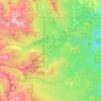
Nombre: Mapa topográfico Allenspark, altitud, relieve.
Lugar: Allenspark, Boulder County, Colorado, United States (40.12942 -105.67155 40.26128 -105.41062)
Altitud media: 2 874 m
Altitud mínima: 1 996 m
Altitud máxima: 4 333 m
Otros mapas topográficos
Haga clic en un mapa para ver su topografía, su altitud y su relieve.
Longs Peak
United States > Colorado > Boulder County
Together with nearby Mount Meeker, with an elevation of 13,911 feet, the two mountains are sometimes referred to as the Twin Peaks (not to be confused with a nearby lower mountain called Twin Sisters).
Altitud media: 3 825 m
Monument Hill
United States > Colorado > Boulder County
Monument Hill or Black Forest Divide Pass is a 7,352 feet (2,241 m) elevation mountain pass in the Palmer Divide in central Colorado in the United States. The pass dividing the Arkansas River drainage system to the south and the Platte River drainage system to the north is the high point on I-25 between Denver…
Altitud media: 2 315 m
Boulder
United States > Colorado > Boulder County > Boulder
Boulder is located at the base of the foothills of the Rocky Mountains, at an elevation of 5,430 feet (1,655 m) above sea level. Boulder is 25 miles (40 km) northwest of the Colorado State Capitol in Denver. It is home of the main campus of the University of Colorado, the state's largest university.
Altitud media: 1 977 m
Nederland
United States > Colorado > Boulder County
In 1873 the Caribou Mine, at an elevation of roughly 10,000 feet (3,000 m) and 6 miles (10 km) northwest of the town, was sold to the Mining Company Nederland from the Netherlands. The high elevation meant fierce winds and deep winter snow, so the new owners of the mine decided that it was beneficial to bring…
Altitud media: 2 578 m
National Center for Atmospheric Research
United States > Colorado > Boulder County > Boulder
Altitud media: 1 816 m
Longs Peak
United States > Colorado > Boulder County
Together with nearby Mount Meeker, with an elevation of 13,911 feet, the two mountains are sometimes referred to as the Twin Peaks (not to be confused with a nearby lower mountain called Twin Sisters).
Altitud media: 3 825 m
South Boulder Canyon Ditch
United States > Colorado > Boulder County > Lafayette
Altitud media: 1 618 m