
Haz una donación
Mapa topográfico Topeka
Haga clic en el mapa para ver la altitud.
Haz una donación
Topeka
Topeka is characterized by a gently rolling terrain that transitions between the floodplain of the Kansas River and the surrounding uplands. The city sits at an elevation of approximately 938 feet (286 meters) above sea level, with its landscape shaped by a mix of prairies and woodlands, particularly in the more northern regions. The Kansas River, flowing through the heart of the city, contributes to the area's topographical variety, creating both low-lying riverbanks and elevated areas such as Burnett's Mound, which offers panoramic views of the city and beyond. The region experiences a humid continental climate, influencing the vegetation and natural features, while the proximity to the Flint Hills to the east adds to the scenic diversity of the landscape.
Haz una donación
Acerca de este mapa
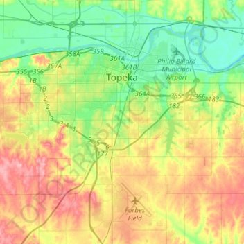
Nombre: Mapa topográfico Topeka, altitud, relieve.
Lugar: Topeka, Shawnee County, Kansas, United States (38.91719 -95.81226 39.10940 -95.60194)
Altitud media: 302 m
Altitud mínima: 259 m
Altitud máxima: 364 m
Haz una donación
Otros mapas topográficos
Haga clic en un mapa para ver su topografía, su altitud y su relieve.