
Haz una donación
Mapa topográfico Les Cours
Haga clic en el mapa para ver la altitud.
Haz una donación
Acerca de este mapa
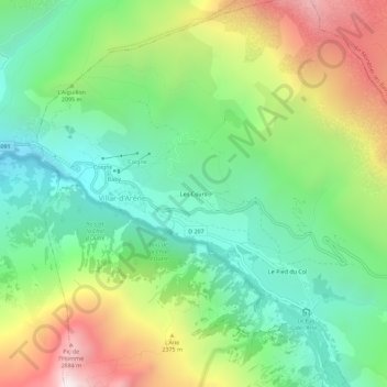
Nombre: Mapa topográfico Les Cours, altitud, relieve.
Altitud media: 2 030 m
Altitud mínima: 1 476 m
Altitud máxima: 3 003 m
Haz una donación
Otros mapas topográficos
Haga clic en un mapa para ver su topografía, su altitud y su relieve.
Glacier d'Arsine
France > Provence-Alpes-Côte d'Azur > Hautes-Alpes > Villar-d'Arêne
Altitud media: 2 851 m
Glacier de la Plate des Agneaux
France > Provence-Alpes-Côte d'Azur > Hautes-Alpes > Villar-d'Arêne
Altitud media: 2 941 m
Jardin botanique alpin du Lautaret
France > Provence-Alpes-Côte d'Azur > Hautes-Alpes > Villar-d'Arêne
Le jardin botanique du col du Lautaret est un jardin botanique alpin d'altitude (2 100 mètres) du massif alpin, situé au col du Lautaret, sur le territoire de la commune de Villar-d'Arêne, dans le département français des Hautes-Alpes. Il est l'un des plus anciens jardins botaniques alpins d'Europe.
Altitud media: 2 177 m