
Mapa topográfico Mettmenstetten
Mapa interactivo
Haga clic en el mapa para ver la altitud.
Acerca de este mapa
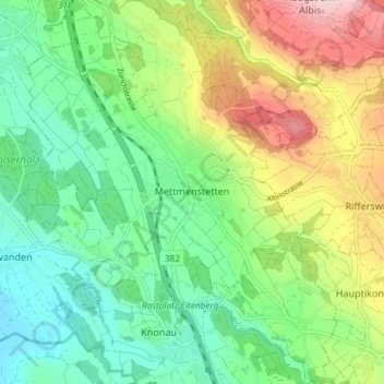
Nombre: Mapa topográfico Mettmenstetten, altitud, relieve.
Lugar: Mettmenstetten, Bezirk Affoltern, Zurich, 8932, Switzerland (47.21838 8.43208 47.26832 8.50067)
Altitud media: 506 m
Altitud mínima: 389 m
Altitud máxima: 727 m
The municipality includes the village of Mettmenstetten, with the two core sections of Ober- and Untermettmenstetten as well as the other sections; Dachlissen, Eigi, Grossholz, Herferswil, Hübscheren, Rossau and Wissenbach. It is located an elevation of 460 m (1,510 ft).
Otros mapas topográficos
Haga clic en un mapa para ver su topografía, su altitud y su relieve.
Aeugst am Albis
Switzerland > Zurich > Bezirk Affoltern
Aeugst am Albis, Bezirk Affoltern, Zurich, Switzerland
Altitud media: 668 m
Wängibad
Switzerland > Zurich > Bezirk Affoltern > Aeugst am Albis
Wängibad, Aeugst am Albis, Bezirk Affoltern, Zurich, 8914, Switzerland
Altitud media: 595 m