
Mapa topográfico Gorey
Mapa interactivo
Haga clic en el mapa para ver la altitud.
Acerca de este mapa
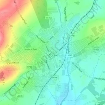
Nombre: Mapa topográfico Gorey, altitud, relieve.
Altitud media: 60 m
Altitud mínima: 28 m
Altitud máxima: 126 m
Otros mapas topográficos
Haga clic en un mapa para ver su topografía, su altitud y su relieve.
The Municipal District of Enniscorthy
The Municipal District of Enniscorthy, Comté de Wexford, Leinster, Irlande
Altitud media: 108 m
Saint Vogue's
Saint Vogue's, Lady's Island ED, The Borough District of Wexford, Comté de Wexford, Leinster, Irlande
Altitud media: 3 m
The Borough District of Wexford
The Borough District of Wexford, Comté de Wexford, Leinster, Irlande
Altitud media: 29 m
Bellary
Bellary, Duncormick ED, The Borough District of Wexford, Comté de Wexford, Leinster, Irlande
Altitud media: 13 m