
Gracias por apoyar a este sitio ❤️
Haz una donación
Haz una donación
Mapa topográfico Nitmiluk National Park
Haga clic en el mapa para ver la altitud.
Gracias por apoyar a este sitio ❤️
Haz una donación
Haz una donación
Acerca de este mapa
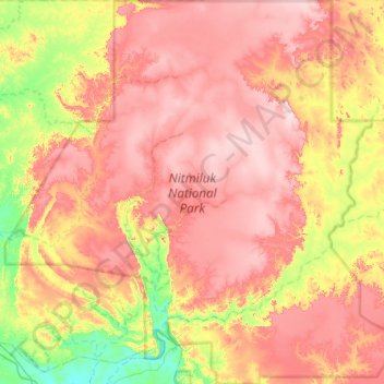
Nombre: Mapa topográfico Nitmiluk National Park, altitud, relieve.
Altitud media: 245 m
Altitud mínima: 103 m
Altitud máxima: 363 m
Gracias por apoyar a este sitio ❤️
Haz una donación
Haz una donación
Otros mapas topográficos
Haga clic en un mapa para ver su topografía, su altitud y su relieve.
Alice Springs
Australia > Northern Territory > Alice Springs
Temperatures in Alice Springs vary widely, and rainfall can vary quite dramatically from year to year. In summer, the average maximum temperature is in the mid-30s, whereas in winter the average minimum temperature can be 5.5 °C (41.9 °F), with an average of 12.4 nights below freezing every year, providing…
Altitud media: 631 m