Geolocalizar

Mapa topográfico Winterthur

Mapa interactivo

Haga clic en el mapa para ver la altitud.

Acerca de este mapa

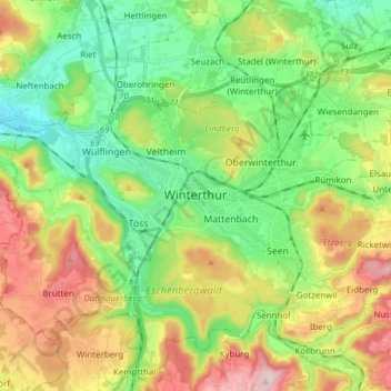
Nombre: Mapa topográfico Winterthur, altitud, relieve.

Lugar: Winterthur, Bezirk Winterthur, Zurich, Switzerland (47.44972 8.65661 47.54800 8.80994)

Altitud media: 504 m

Altitud mínima: 390 m

Altitud máxima: 696 m

Winterthur is located at an elevation of 439 meters (1,440 ft). The city is located in a basin south and east of the river Töss before it meets the High Rhine after 10 kilometers. The Eulach, a small river, flows from the town's east end through the middle of the town to meet the Töss at the west exit of the city. Because of this the town is colloquially also called "Eulachstadt". Zürich lies about 20 km (12 mi) southwest of Winterthur.

Wikipedia (CC-BY-SA 3.0)

Otros mapas topográficos

Haga clic en un mapa para ver su topografía, su altitud y su relieve.

Ellikerbach

Switzerland > Zurich > Bezirk Winterthur > Ellikon an der Thur

Ellikerbach, Untergris, Ellikon an der Thur, Bezirk Winterthur, Zurich, 8548, Switzerland

Altitud media: 400 m