
Mapa topográfico Versalles
Mapa interactivo
Haga clic en el mapa para ver la altitud.
Versalles
Versalles se localiza a 16,8 km al oeste-sudoeste del centro de París (en línea recta). La ciudad se asienta sobre una meseta elevada de 394 a 140 metros sobre el nivel del mar (mientras que la altitud del centro de París es sólo 33 m sobre el nivel de mar), rodeada por colinas boscosas: en el norte los bosques de Marly y Fausses-Reposes, en el sur los bosques de Satory y en el este los bosques de Meudon y de Vélizy.
Acerca de este mapa
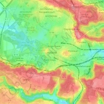
Nombre: Mapa topográfico Versalles, altitud, relieve.
Altitud media: 142 m
Altitud mínima: 99 m
Altitud máxima: 185 m