
Mapa topográfico Porto Alegre
Mapa interactivo
Haga clic en el mapa para ver la altitud.
Porto Alegre
El área del municipio de Porto Alegre es de 495.39 km² (IBGE/2022). De este total, 44.45 km² están distribuidos en las 16 islas sobre el río Guaiba. Actualmente la ciudad cuenta con 94 barrios. Posee un relieve algo montañoso en el extremo sur, presentando pequeños cerros, el más grande de ellos es el Morro Santana, con 311 m s. n. m. de elevación. La ciudad aún posee 70 km de costas bañadas por el Guaiba.
Acerca de este mapa
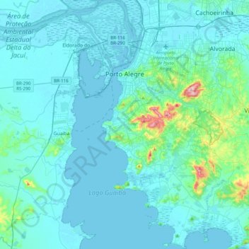
Nombre: Mapa topográfico Porto Alegre, altitud, relieve.
Altitud media: 26 m
Altitud mínima: -1 m
Altitud máxima: 309 m