Geolocalizar

Mapa topográfico Crans-Montana

Mapa interactivo

Haga clic en el mapa para ver la altitud.

Acerca de este mapa

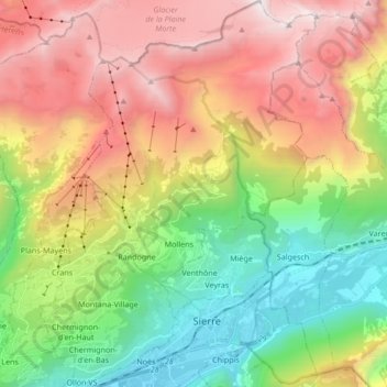
Nombre: Mapa topográfico Crans-Montana, altitud, relieve.

Lugar: Crans-Montana, Sierre, Wallis, 3960, Switzerland (46.27218 7.45877 46.38897 7.58017)

Altitud media: 1 660 m

Altitud mínima: 508 m

Altitud máxima: 3 155 m

The resort is located in the heart of the Swiss Alps in the French-speaking part of the canton of Valais. It is located on a plateau above Sierre at an elevation of about 1,500 m (4,920 ft) above sea level, allowing good view over the Valais Alps and Weisshorn in particular. The resort is a fusion of the two centers of Crans and Montana and belongs to 6 municipalities (Chermignon, Icogne, Lens, Mollens, Montana and Randogne).

Wikipedia (CC-BY-SA 3.0)

Otros mapas topográficos

Haga clic en un mapa para ver su topografía, su altitud y su relieve.

Lac de Chermignon

Switzerland > Wallis > Sierre > Plans-Mayens

Lac de Chermignon, Plans-Mayens, Lens, Sierre, Wallis, 3960, Switzerland

Altitud media: 1 548 m

Lac de Châteaupré

Switzerland > Wallis > Sierre > Anniviers

Lac de Châteaupré, Anniviers, Sierre, Wallis, 3961, Switzerland

Altitud media: 2 646 m

Zinal

Switzerland > Wallis > Sierre > Anniviers

Zinal, Anniviers, Sierre, Wallis, 3961, Switzerland

Altitud media: 2 209 m

Chandolin

Switzerland > Wallis > Sierre > Anniviers

Chandolin, Anniviers, Sierre, Wallis, 3961, Switzerland

Altitud media: 1 901 m

Randogne

Switzerland > Wallis > Sierre > Crans-Montana

Randogne, Crans-Montana, Sierre, Wallis, 3960, Switzerland

Altitud media: 1 614 m

Couronne de Bréona

Switzerland > Wallis > Sierre > Anniviers

Couronne de Bréona, Anniviers, Sierre, Wallis, 3961, Switzerland

Altitud media: 2 720 m

Sierre

Switzerland > Wallis > Sierre

Sierre, Wallis, 3960, Switzerland

Altitud media: 1 143 m