Geolocalizar

Mapa topográfico Karachi

Mapa interactivo

Haga clic en el mapa para ver la altitud.

Acerca de este mapa

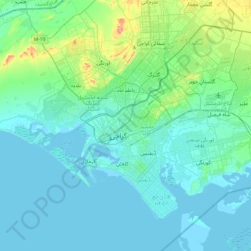
Nombre: Mapa topográfico Karachi, altitud, relieve.

Lugar: Karachi, Sindh, 74400, Pakistan (24.69468 66.86071 25.01468 67.18071)

Altitud media: 20 m

Altitud mínima: -4 m

Altitud máxima: 173 m

Karachi lies very close to a major fault line, where the Indian tectonic plate meets the Arabian tectonic plate. Within the city of Karachi are two small ranges: the Khasa Hills and Mulri Hills, which lie in the northwest and act as a barrier between North Nazimabad and Orangi. Karachi's hills are barren and are part of the larger Kirthar Range, and have a maximum elevation of 528 metres (1,732 feet).

Otros mapas topográficos

Haga clic en un mapa para ver su topografía, su altitud y su relieve.

K-IV Canal

Pakistan > Sindh > Karachi

K-IV Canal, Karachi, Sindh, Pakistan

Altitud media: 100 m

Sandspit

Pakistan > Sindh > Karachi > کاکا پیر

Sandspit, کاکا پیر, Karachi, Sindh, Pakistan

Altitud media: 1 m

Liquatabad Town

Pakistan > Sindh > Karachi

Liquatabad Town, Karachi, Karāchi District, Sindh, 75900, Pakistan

Altitud media: 25 m