Geolocalizar

Mapa topográfico Menzingen

Mapa interactivo

Haga clic en el mapa para ver la altitud.

Acerca de este mapa

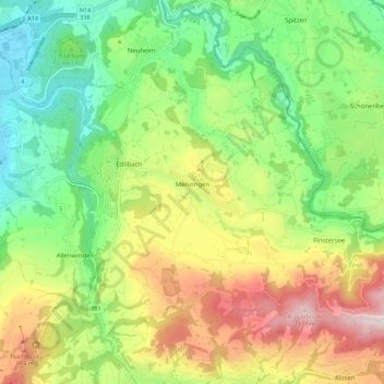
Nombre: Mapa topográfico Menzingen, altitud, relieve.

Lugar: Menzingen, Zug, 6313, Switzerland (47.14806 8.55440 47.20524 8.66577)

Altitud media: 740 m

Altitud mínima: 443 m

Altitud máxima: 1 195 m

The municipality is located on a moraine plateau between the Lorze and Sihl rivers at an elevation of about 800 m (2,600 ft). In 1848 the municipality of Neuheim separated from Menzingen. It consists of the village of Menzingen and a number of hamlets and individual farm houses.

Wikipedia (CC-BY-SA 3.0)

Otros mapas topográficos

Haga clic en un mapa para ver su topografía, su altitud y su relieve.

Zug

Switzerland > Zug > Zug

Zug, Switzerland

Altitud media: 640 m

Baar

Switzerland > Zug > Baar > Baar

Baar, Zug, Switzerland

Altitud media: 534 m