
Mapa topográfico Himachal Pradesh
Mapa interactivo
Haga clic en el mapa para ver la altitud.
Acerca de este mapa
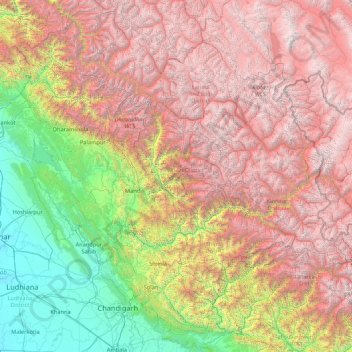
Nombre: Mapa topográfico Himachal Pradesh, altitud, relieve.
Lugar: Himachal Pradesh, India (30.37717 75.59401 33.25567 79.01238)
Altitud media: 2 869 m
Altitud mínima: 232 m
Altitud máxima: 6 687 m
Due to extreme variation in elevation, great variation occurs in the climatic conditions of Himachal. The climate varies from hot and humid subtropical in the southern tracts to, with more elevation, cold, alpine, and glacial in the northern and eastern mountain ranges. The state's winter capital, Dharamsala receives very heavy rainfall, while areas like Lahaul and Spiti are cold and almost rainless. Broadly, Himachal experiences three seasons: summer, winter, and rainy season. Summer lasts from mid-April till the end of June and most parts become very hot (except in the alpine zone which experiences a mild summer) with the average temperature ranging from 28 to 32 °C (82 to 90 °F). Winter lasts from late November till mid-March. Snowfall is common in alpine tracts. Pollution is affecting the climate of almost all the states of India. Due to steps taken by governments to prevent pollution, Himachal Pradesh has become the first smoke-free state in India which means cooking in the entire state is free of traditional chulhas.
Otros mapas topográficos
Haga clic en un mapa para ver su topografía, su altitud y su relieve.
Bengaluru
India > Karnataka > Bangalore North
Bengaluru, Bangalore North, Bengaluru Urban District, Karnataka, India
Altitud media: 881 m
3d
India > Rajasthan > Ganganagar Tehsil > 1 LNP
3d, 1 LNP, Ganganagar Tehsil, Sri Ganganagar District, Rajasthan, India
Altitud media: 178 m
North Sentinel Island
India > Andaman and Nicobar Islands > Ferrargunj
North Sentinel Island, Ferrargunj, South Andaman District, Andaman and Nicobar Islands, India
Altitud media: 20 m
Kottakombur
Kottakombur, Devikulam, Idukki District, Kerala, India
Altitud media: 1 919 m
Prayagraj
India > Uttar Pradesh > Prayagraj
Prayagraj, Prayagraj District, Uttar Pradesh, 211001, India
Altitud media: 91 m
Gurgaon
India > Haryana > Gurugram District
Gurgaon, Gurugram District, Haryana, India
Altitud media: 237 m
Mat
India > Uttar Pradesh > Mathura District
Mat, Mathura District, Uttar Pradesh, India
Altitud media: 182 m
Mysuru
India > Karnataka > Mysuru taluk
Mysuru, Mysuru taluk, Mysuru District, Karnataka, 570001, India
Altitud media: 727 m
Bachupally mandal
Bachupally mandal, Medchal–Malkajgiri District, Telangana, 500090, India
Altitud media: 593 m
Western Ghats
Western Ghats, Idukki, Kerala, 685614, India
Altitud media: 2 225 m
Maduranthakam
Maduranthakam, Chengalpattu District, Tamil Nadu, India
Altitud media: 37 m
Vijayawada
India > Andhra Pradesh > Vijayawada (Urban)
Vijayawada, Vijayawada (Urban), NTR District, Andhra Pradesh, 520001, India
Altitud media: 36 m
Indore
India > Madhya Pradesh > Juni Indore Tahsil
Indore, Juni Indore Tahsil, Indore District, Madhya Pradesh, 452001, India
Altitud media: 555 m
Pune
India > Maharashtra > Pune City > Pune
Pune, Pune City, Pune District, Maharashtra, 411001, India
Altitud media: 641 m
Akpa
India > Himachal Pradesh > Moorang
Akpa, Moorang, Kinnaur District, Himachal Pradesh, 172116, India
Altitud media: 2 709 m
Walmara
India > Uttarakhand > Syalde
Walmara, Syalde, Almora District, Uttarakhand, 263661, India
Altitud media: 1 043 m
Thuneri
India > Tamil Nadu > Udhagamandalam
Thuneri, Udhagamandalam, Nilgiris District, Tamil Nadu, 643402, India
Altitud media: 1 899 m
Tharangambadi
Tharangambadi, Mayiladuthurai District, Tamil Nadu, India
Altitud media: 5 m
Thiruvananthapuram
India > Kerala > Thiruvananthapuram
Thiruvananthapuram, Thiruvananthapuram District, Kerala, 695001, India
Altitud media: 33 m