
Mapa topográfico Austerlitz
Mapa interactivo
Haga clic en el mapa para ver la altitud.
Acerca de este mapa
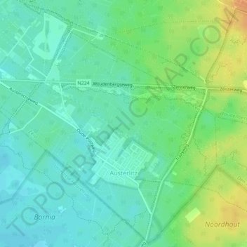
Nombre: Mapa topográfico Austerlitz, altitud, relieve.
Lugar: Austerlitz, Zeist, Utrecht, Nederland (52.07033 5.29088 52.09645 5.33262)
Altitud media: 20 m
Altitud mínima: 8 m
Altitud máxima: 43 m
Otros mapas topográficos
Haga clic en un mapa para ver su topografía, su altitud y su relieve.
Huis ter Heide
Huis ter Heide, Zeist, Utrecht, Nederland
Altitud media: 12 m
Slot Zeist
Slot Zeist, slotplein, Zeist, Utrecht, Nederland, 3703DX, Nederland
Altitud media: 6 m