
Mapa topográfico Karachi Division
Mapa interactivo
Haga clic en el mapa para ver la altitud.
Acerca de este mapa
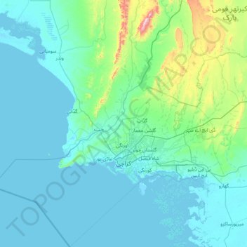
Nombre: Mapa topográfico Karachi Division, altitud, relieve.
Lugar: Karachi Division, Sindh, Pakistan (24.42735 66.28623 25.67680 67.55541)
Altitud media: 89 m
Altitud mínima: -2 m
Altitud máxima: 1 065 m
Karachi lies very close to a major fault line, where the Indian tectonic plate meets the Arabian tectonic plate. Within the city of Karachi are two small ranges: the Khasa Hills and Mulri Hills, which lie in the northwest and act as a barrier between North Nazimabad and Orangi. Karachi's hills are barren and are part of the larger Kirthar Range, and have a maximum elevation of 528 metres (1,732 feet).
Otros mapas topográficos
Haga clic en un mapa para ver su topografía, su altitud y su relieve.
Gulistan-e-Jauhar
Gulistan-e-Jauhar, Gulshan Town, Sindh, 75300, Pakistan
Altitud media: 37 m
DHA Phase 7
DHA Phase 7, Defence, Karachi, Sindh, 77500, Pakistan
Altitud media: 7 m
Paradise Point
Paradise Point, KNPC, Sindh, Karachi Division, Pakistan
Altitud media: 7 m
Landhi Town
Landhi Town, Karachi, Karāchi District, Sindh, 75120, Pakistan
Altitud media: 19 m
Indus River
Indus River, Lab-e-Mehran Road, Old Sukkur, Sukkur, Shikārpur District, Sindh, Pakistan
Altitud media: 64 m