
Gracias por apoyar a este sitio ❤️
Haz una donación
Haz una donación
Mapa topográfico Longmont
Haga clic en el mapa para ver la altitud.
Gracias por apoyar a este sitio ❤️
Haz una donación
Haz una donación
Longmont
The elevation at City Hall is 4,978 feet (1,517 m) above sea level. St. Vrain Creek, a tributary of the South Platte River, flows through the city just south of the city center.
Gracias por apoyar a este sitio ❤️
Haz una donación
Haz una donación
Acerca de este mapa
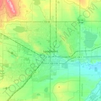
Nombre: Mapa topográfico Longmont, altitud, relieve.
Lugar: Longmont, Boulder County, Colorado, 80501, United States (40.12639 -105.17838 40.20996 -105.01732)
Altitud media: 1 534 m
Altitud mínima: 1 483 m
Altitud máxima: 1 649 m
Gracias por apoyar a este sitio ❤️
Haz una donación
Haz una donación
Otros mapas topográficos
Haga clic en un mapa para ver su topografía, su altitud y su relieve.